
A bit of GR11 slackpacking
Arrived back in the UK a week ago having spent 5½ weeks ambling in the Pyrenees primarily along the GR11. Originally I looked at a shorter trip, ~4 weeks, finishing in Puigcerda (end of day 35) but ease of transport & the thought that some days wandering through Basque country would tone the fitness saw me start in Irun. It ended up that despite by best slackpacking efforts (ambling into town & enjoying the Menú del día, €10 – 14 for a 3 course lunch including a bottle of wine, became a regular feature) & intentionally wandering off the GR11 quite a few times, I ended up spending nearly a week in the mountains east of Puigcerda.
The first week saw brutal temperatures 33 – 35C; lowest overnight temp was ~0C (grass frost); frequent afternoon thunderstorms; 2 days of nonstop torrential rain; generally in the high mountains the weather was pretty good; snow was markedly absent (much less than 2014).
I met lots of nice people on the trail; probably >60 – 70% were just doing a section (1 or 2 weeks); very few were travelling light weight most were carrying 18 – 20kg & making hard work of it.
My opinion of the GR11? Physically there are some tough days with big climbs, navigation is straightforward (there are all these Red/ White flashes everywhere), lots of days are spent on easy tracks, resupply is straightforward (though don’t expect too much at some of the small shops) & the Brian Johnson’s GR11 Trail Guide is excellent. Overall it’s a nice route passing through spectacular scenery BUT when compared with the HRP I’d only score give it 6/10.
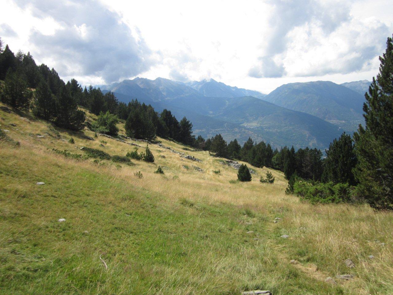
No day by day account just some photo’s, probably not 100% representative of the overall trail (no pics of forestry roads, civilisation, etc).
Just click on the pics to view full size
Picnic area c/w a ‘Franco’ border bunker (Stage 2/ 3:30hrs), a nice shady spot for lunch.

The wooded Basque country hills (Stage 3)

The Sierra de Abodi ridge, East of Hiriberri (Stage 6), clearing after the storm.

Further East of the Sierra de Abodi ridge.

Paso de Las Alforjas (Stage 6), the big stuff getting closer

East of Ochagavia (Stage 7)


Valle de Aspe (Stage 8) lots of camping (& cattle).

Descent to Cananchu (Stage 10)


Plano d’a Rinconada (Stage 11/ 2:40)

Ibon d’ Anayet. (Stage 11/ 3:50)

Ibon de Llena Cantal & the unpleasant climb to Cuello de Tebarrai (Stage 13)

Guided parties heading West to Cuello de Tebarrai

Storms brewing over the Ibon dero Brazato (Stage 14)

Descending down the Rio Ara (Stage 14)

The GR11 climbs high above the Rio Ara, East (Stage 15)

The lower Ordesa Canyon (Stage16)

The upper Ordesa Canyon (Stage16)

Down the Ordesa Canyon from near the Goriz Refuge(Stage 17)

Storm brewing of Perdido from Collata Anisclo (Stage 17)

Ibon Inferior de Ballibierna (Stage 20)

Ibon Cap de Llauset (Stage 21)

Off the GR11 near the Refugio d’Anglios

Camp about 1hr from Refugi dera Restanca(Stage 22)

Descent toward Refugi de Colomers (Stage 23)


Lac Long (Stage 24)

Storm in the Port de Ratera (Stage 24)

Old mule track to Tavascan (Stage 27)
East of Tavascan (Stage 28)
Camp East of Tavascan (Stage 28)

Crumbing mule track on route to Boldis Subira (Stage 28)

Ascending towards the Refugi de Baiau (Stage 30)

The Refugi de Baiau

Descent to Encamp near Coll d’Ordino (Stage 32)

Above the Refugi de Fortverd, great camping & more cattle (Stage 33)

Granite landscape near Refugio de L’Illa (Stage 33)

Cabana dels Esparvers (Stage 34)

Pia de la Feixa with the Refugi de la Feixa bothy just visible (Stage 35)

Pic de Finestrelle from the summit of Puigmal (off the GR11)

Cim de la Coma Del Clot from Coll de Noucreus (Stage 38)

Chamois on the slopes of Cim de la Coma Del Clot

Camí Dels Enginyers (Engineers Way) from Refugi Coma de Vaca to Nuria (off the GR11)


The road to west back to Puigcerda & home (Stage 36)


Lovely pictures, as usual Paul, thanks. How did you manage for water on that route, it looks pretty arid?
Water really wasn’t a big issue, the guide has good info of where water can be found. On some days I have to carry a couple of litres & on a couple of occasions packed 5L for 3 – 4hrs (enough for the rest of the day, overnight + the next day). Got in the habit of filtering all the water, lots of livestock about (cows, horses & sheep) even at 3000m & some of the toilet habits of people on the trail beggared belief, better safe than sorry!
Looks great Paul. We are off there next week for 15days walking. Starting in France then over to Candanchu to stay over in Spain for a week+ then back into France (we have return train tickets to Pau ). Possibly some HRP.
Hope you have good weather, the line of the HRP is far superior IMO.
Hi Paul, just caught up with this, some great pictures despite the weather! We did an East West crossing mainly HRP with a few side trips and the odd bail due to storms, some of which were by far the biggest we have ever come across, and like you the heat at the start nearly put paid to our adventure after 3 days!
Conclusion….awesome route that I would still do again, West East is best, ditch Joosten and go with Veron and have enough time to sit the storms out so we can do all the ridges we want to!
Did the Joosten HRP route in 2014 & now have a copy of Veron. Thinking of going back in 2016 & making up my own variations.
There is a lot to choose from and the Pyrenees do become addictive 😉 I think we will aim for something a little less committing next year, a few peaks and some climbing, but we keep looking at the maps for our dream crossing route, one day soon.
Great seeing your pics of tne GR11. We did the route (with a couple of small gaps) coast to coast over 2 months last summer. We were very impressed at the landscape diversity and the level of landscape ‘quality’ that was maintained over such a long distance. A classic mountain journey and yes, Brian Johnson’s guide was great. We’re hitting the GR1 ‘Sendero Historico’ across Spain this spring, traversing lower sierras, but with lots of culture and remote villages, we’ll be recording progress on our blog again also.
Hi Paul, we are planning on doing around a week of the GR11 from mid juli. We did the Houte Route in Schwizerland 2 years ago and Corse last summer. We love the rough Mountains, and I am wondering if you can recommend where to start and end our trek this summer. We are thinking of ending in Puigcerda according to the possibility of transportation and walking West. We have the “bible” of Brian Johnson, but it is hard to see how to shorten the GR11.
BR Lenette
A 1 week trip is definitely hard to figure out using public transport to/ from the start & finish points particularly since you’ll may lose time at each end travelling; much easier to have the route ‘choose’ the duration.
One thought is to walk East from Puigcerda to Arinsal on GR11 (you could use the bus between Encamp & Arinsal if you needed to shorten the route) then you could pick up the Joosten HRP heading East to Hospitalet-Pres-L’Andorre from where you can get the train back to Latour de Carol/ Puigcerda.
Hi. Thanks for your answer. We have around 2 weeks alltogether, so one week for the trek excluding transportation. I notised you mentioned in your trip description that you meet a lot of people who only spent 1-2weeks on gr11?
How about this for an idea.
There’s an ALSA bus service to El Pont de Suer from where during the summer there’s the ‘Parc Bus’ that runs over to Espot (2 per day, around 10am & 6pm), take this 25km North to the Refugi de Conangles from where GR11 Stage 22 starts. Puigcerda is end of Stage 35, doable ???
Thanks a lot. Do you by any chance know where to look up timetables for Thisted transportation?
A good place to look for possible Bus options are Cataluya Tranport Journey planner & Andorra buses
thanks:-)